596.5 miles (960 km) / 27 days on foot

The Vía de la Plata (or Camino de la Plata)

The longest way to Santiago

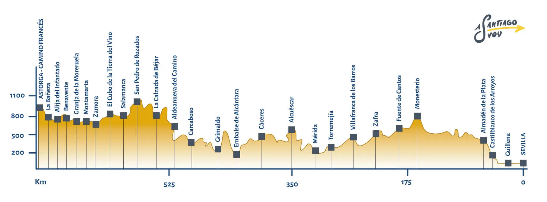
The Vía de la Plata is one of the longest routes to reach Santiago de Compostela, but also one of the richest in history. To overcome this challenge you must go through 38 stages in total: 27 belong to the Vía de la Plata, the last 11 stages belong to the French Way. In this guide we give you some key issues to help you organize your Camino.

In order to complete the Camino de Santiago, you don't have to travel the entire route. You can choose any intermediate departure point and complete the stages and miles you want. If you travel at least 100 km on foot or 200 km by bicycle, you will be awarded with the Compostela upon your arrival in Santiago.


Image: Plaza de España, Sevilla

The Vía de la Plata (or Camino de la Plata)

596.5 miles (960 km) / 37 days on foot / 13 days by bike


The Camino de la Plata is the longest route of the Way of Saint James. You must go through 38 stages to overcome the challenge. Walk through the historic Via de la Plata created by the Romans to ascend to Galicia, and discover the magic of the Camino de Santiago.

The Vía de la Plata gives you the opportunity to tour the Peninsula from south to north, passing through some of the most beautiful locations in Spain. Cities such as Seville, Zafra, Merida, Cáceres, Salamanca, Zamora or Astorga are some of the places you'll discover in this wonderful road.

The Vía de la Plata was already a Roman road that was used for commercial reasons to connect Mérida with Astorga. Since it crossed a good part of Hispania, from south to north, it is not surprising that the old pilgrims used it to get to Santiago. Historically speaking, the Vía de la Plata began in Mérida. It was later on when it stretched to Seville. Only later, the Vía de la Plata swift its starting point - from Mérida to Seville, after the Christianization of the Mozarabic territories.

camino francés

Characteristics of the Vía de la Plata

The Camino de la Plata (or Vía de la Plata) begins in Seville and ends in Santiago. Since it crosses all the Spanish territory from south to north, it is not surprising that it is the longest road to Compostela. Its 596.5 miles are divided into 38 stages on foot and 16 by bicycle. Its shortest stage (the 9th) has 9.9 miles. The longest, 23.9 miles. Most stages are long, over 18 miles. If you have days to spare, you should know almost all the long stages are divisible into two parts. However, this adds extra days to this long journey.

The Vía de la Plata is characterized by being properly signposted. You will find the famous yellow scalop arrows without problems, so the circulation is comfortable and it is very unlikely that you will deviate.

Another important fact is the temperature. As you know, the temperatures in the southern Spain are extreme in summer. You must bear in mind that the road passes through stages without shade, flat and hard. If you are going to travel this route, we recommend you to prepare well if you travel in summer. You should always consider hydration and sunscreen.

Cáceres

Mérida

Salamanca

Zamora

Stages of the Via de la Plata

The Camino de la Plata is composed of 38 stages. We explain them briefly so you know what to expect every day.

From Sevilla

Stage 1
Sevilla - Guillena (14.16 miles / 22.8 km)

This stage is characterized by being flat and pleasant. It's not only free of obstacles, but also full of gorgeous locations. Starting the Way of Saint James in one of the most beautiful cities in Spain will serve as motivation and it will make you live the Camino in a way you could have never imagined. Before leaving, go discover the beauty of Seville and enjoyr its delicacies. The places of interest do not end in the old Hispalis, but you can continue enjoying them in towns such as Santiponce or Guillena, the end of the stage.

Stage 2
Guillena - Castilblanco de los Arroyos (11.3 miles / 18.2 km)

This stage does not involve obstacles or slopes. In addition, it is quite short, so it is a good start to the Camino. Take advantage of this type of stage to enjoy the landscapes and the unique gastronomy: gazpacho, salmorejo, migas, aceitadas, tortas sobás... There are a zillion delicacies that you can try on this route.

Stage 3
Castilblanco de los Arroyos - Almadén de la Plata (17.8 miles / 28.8 km)

This area has wide pastures (dehesas) and fields dedicated to cattle industry. You will pass through charming places, including the Berrocales Natural Park. Given the high quality of the stock, we recommend you to try the Iberian meats, if you can.

Stage 4
Almadén de la Plata - Monesterio (21.3 miles / 34.4 km)

This is where the Extremaduran path begins, leaving behind the beautiful community of Andalusia. This is a long stage, with almost 22 miles. Here you will cross pastures and agricultural and cattle fields. At the end of the stage, there is a slope. Get ready for it by eating well: pork meat is the specialty of the area you're in.

Stage 5
Monesterio - Fuente de Cantos (13.1 miles / 21.2 km)

In this stage there is a descent until you reach the Bodión stream. Although the presence of water softens the temperatures, don't neglect the weather conditions: always walk hydrated and wear sunscreen. This stage, like many others on this route, has long parts without shade and extreme temperatures.

Stage 6
Fuente de Cantos - Zafra (15.2 miles / 24.6 km)

In this stage you won't find steep slopes. It runs between streams, so the landscape is pleasant and natural and the temperatures cool thanks to its humidity. Upon arrival, you will have the opportunity to see Zafra, a city in Extremadura worth discovering.

Stage 7
Zafra - Villafranca de los Barros (11.9 miles / 19.2 km)

This stage is simple: it is short, with less than 20 km and without inclinations or obstacles. The arrival town is Villafranca de los Barros, a charming location popularly known as the "City of Music". When wandering around this town you will surely have the opportunity to listen to live music on the streets while you enjoy the beauty of its architecture.

This short stage can be extended, by convering 10.5 more miles until reaching Almendralejo. Being flat and short, you can extend it or you can stop to rest and visit Villafranca de los Barros and leave Almendralejo for the next day.

Stage 8
Villafranca de los Barros - Torremejía (16.7 miles / 27 km)

On this day, you will go to Almendralejo, where we recommend you to visit the Church of the Heart of Mary and the Convent of Santa Clara. This stage is long. However, it is flat and without obstacles, so it does not harbor difficulties.

Stage 9
Torremejía - Mérida (9.9 miles/16 km)

In this stage you can enjoy this historical area, rich in architectural remains from the Roman Empire. Do not hesitate to visit the many monuments of Mérida: the Roman Theater, the Amphitheater and the Temple of Diana, among others. Being a short stage, we recommend that you take time to visit this city, a cultural heritage site.

From Mérida

Stage 10
Mérida - Alcuéscar (22.6 miles / 36.4 km)

After resting during the previous stage, you will have to be ready for this one, with more than 21 miles awaiting. In this stage, you will pass through the Natural Park of Cornalvo and numerous Roman archaeological remains, such as the Roman reservoir of Proserpina. In this stage you will go from Badajoz to Cáceres, the finish line being the town of Alcuéscar. Stop to visit its hermitages and the Church of Santa Lucía del Trampal.

Stage 11
Alcuéscar - Cáceres (20.3 miles / 38.2 km)

On the 11th day another long stage awaits, and it can be divided into two parts. You can choose to spend the night in Aldea del Cano (after the 9th mile) or in Valdesalor (after the 15th mile). If you want to complete it, you can spend the night in Cáceres after a 23-mile hike. Although the stage is long, it is flat and pleasant. If you choose to divide it into two parts, do not hesitate to spend some time visiting the city of Cáceres.

From Cáceres

Stage 12
Cáceres - Embalse de Alcántara (20.7 miles / 33.4 km)

Depending on where you stopped in the previous stage, you will leave Cáceres or Casar de Cáceres. When you change the starting point, the point of arrival also changes: you can stop at the Embalse de Alcántara or at Cañaveral.

Stage 13
Embalse de Alcántara - Grimaldo (13 miles / 20.9 km)

This stage is not as long as the previous ones. The road has a rise and a fall, but they are not too pronounced or long. The roads are somewhat mountainous and the terrain is muddy.

Stage 14
Grimaldo - Carcaboso (19.1 miles / 30.8 km)

In this stage, you have the option of passing through Riolobos or skiping it. The detour to Riolobos adds some miles to a quite long stage. It is also optional to pass through Galisteo, although you would miss its historic wall. We recommend you to make your decision according to your strength and according to the interest in visiting these locations. In any case, the end of this stage is in Carcaboso

Stage 15
Carcaboso - Aldeanueva del Camino (23.9 miles / 38.6 km)

This long stage is also divisible in two shorter stages. You will have the opportunity to pass through the Roman arch of Cáparra, famous for its historical value and its good state of preservation.

Stage 16
Aldeanueva del Camino - La Calzada de Béjar (13.7 miles / 22.2 km))

This stage is the end of the route along the Community of Extremadura. The town Puerto de Béjar will be the first stop in Castille and León. From there you will continue, until you reach La Calzada de Béjar to spend the night. This stage has a slight rise to Puerto de Béjar, followed by a descent.

Stage 17
La Calzada de Béjar - Fuenterroble de Salvatierra (12.5 miles / 20.2 km)

With so many long stages, these 12-mile stages are an opportunity to rest and appreciate the landscape and the places you visit. We recommend you to stop and taste the cuisine of Castille and León. In this stage you will easily find public services.

Stage 18
Fuenterroble de Salvatierra - San Pedro de Rozados (17.7 miles / 28.6 km)

This stage is characterized by its rise towards Pico de la Dueña, which is almost 4,000 meters above sea level. The climb is not as pronounced as it may seem, since the starting point is almost 3,000 feet above sea level. Then, you will encounter a descend to the stream Mendigos, although you can take a detour that passes through Pedrosillo de los Aires and Monterrubio de la Sierra.

Stage 19
San Pedro de Rozados - Salamanca (14 miles / 23 km)

This stage passes through natural areas: forests and pastures mostly. As you walk, you'll begin to see the city of Salamanca in the distance - a beautiful vision that makes the Camino much more bearable. Thanks to this short stage, you can visit Salamanca calmly. Take your time and discover both to its streets and its gastronomy. Some especially noteworthy places are its Plaza Mayor, the Old Cathedral and the New Cathedral, the San Esteban Convent, the Casa de las Conchas, La Clerecía, etc.

From Salamanca

Stage 20
Salamanca - El Cubo de la Tierra del Vino (22.6 miles / 36.4 km)

We recommend that you get supplies before starting this stage, since it is long and does not have too many public services in the intermediate locations. This is again a rather long stage, very frequent on this path to Santiago. This stage is flat and runs near the highway, practically parallel to the road N-630. The finish line of this stage is El Cubo de la Tierra del Vino. In case you were wondering, the habitants of this place are called "cubinos" and "cubinas".

Stage 21
El Cubo de la Tierra del Vino - Zamora (19.7 miles / 31.8 km)

From this wine town you will move to Zamora in a long and declining stage. Zamora is one of those cities that deserve a more dedicated visit. You can visit its Castle, its Cathedral, the Cordon Palace and many other points of interest on its streets, such as the Plaza de Viriato and its Plaza Mayor. It is also worthwhile to taste their specialties: their products with designation of origin, such as cheeses and wines; and its typical dishes.

Stage 22
Zamora - Montamarta (11.5 miles / 18.6 km)

This area is known as the "land of bread", because of the quality and abundance of cereal fields. It is a short and straightforward stage, in which you can relax without thinking about detours or long kilometers. Taste its typical sweets: aceitadas, rebojos, mantecadas, orejas, bollos... All made with wheat flour, probably coming from the fields that you are seeing along these stages.

Stage 23
Montamarta - Granja de Moreruela (14.2 miles / 22.9 km)

This is a flat and pleasant stage. You will pass through the Ricobayo Reservoir. In this section there are 2 small shortcuts: if you do not want to go through Fontanillas de Castro or Riego del Camino, you can shorten the route and stop directly at Granja de Moreruela. The ruins of its monastery are some of the interesting monuments that you can see here.

In this stage, the road forks: you can choose to follow the original route of the Vía de la Plata or deviate and continue along the Camino Sanabrés and the Camino Francés.

Stage 24
Granja de Moreruela - Benavente (16.9 miles / 27.2 km)

This is another short and peaceful stage, without major obstacles. In addition, here you will have access to useful public services (hotels, accomodation, pharmacies, etc.), so this is a comfortable stage in many ways. You will continue walking by the N-630, until you turn to Benavente at the end of the section. In Benavente you can visit its many points of interest: the Church of Santa María de Azogue, the Church of San Juan del Mercado, the Hospital of Pilgrims of Mercy, the Torre del Caracol or the Castillo de la Mota, the Jardines de la Mota, the Jardines de la Rosaleda, etc.

Stage 25
Benavente - Alija del Infantado (13.6 miles / 21.9 km)

This is a short stage, which runs almost entirely on pavement. You will pass through towns such as Villabrázaro, Maire de Castroponce and Puente de la Vizana. There are not too many services along the way, but the stage is short, so it shouldn't be a problem.

Stage 26
Alija del Infantado - La Bañeza (13.7 miles / 22.1 km)

You continue the route by the Jamuz river flow. This is a short stage, on soily paths easily to walk through. You will pass through agricultural and floral fields.

Stage 27
La Bañeza - Astorga (15.2 miles / 24.5 km)

In this stage you will find some unevenness, but it won't prevent you from moving forward at a good pace. You will leave the river to walk almost parallel to the A-6 road. From the Roman bridge of Valimbre you will have the possibility of going west or east towards Celada de la Vega, the two roads being equally long.

Once you have arrived in Astorga, visit the Episcopal Palace, the Cathedral of Santa María, the Medieval Wall, the Church of San Francisco or the Roman Gate. From this point, the Vía de la Plata merges with the end of the French Way. You will find new pilgrims on the path, coming from the Camino Francés. To be exact, stage 27 corresponds to stage 23 of the French Way.

Stage 28
Astorga - Foncebadón (16 miles / 25.8 km)

You are in the core of an area known as the Country of the Maragatos. Here you will leave behind the flat areas to start climbing the mountains of León. The landscape also changes little by little, filling with green tones and cooler climates. Try the cocido maragato, one of the most typical specialties in the area.

Stage 29
Foncebadón - Ponferrada (16.6 miles / 26.8 km)

The passage from Foncebadón to Ponferrada is a considerable descent, from more than 4,200 feet above sea level to more than 900 feet. You will pass through towns such as Manjarín, El Acebo de San Miguel, Riego de Ambrós and Molinaseca. Once in Ponferrada, do not miss the Templarios Castle, the Basilica de la Encina or the Clock Tower.

Stage 30
Ponferrada - Vilafranca del Bierzo (16.6 miles / 24.2 km)

We cross the region of El Bierzo passing through Columbriados, Fuentesnuevas, Camponaraya and Cacabelos. This area is located in a basin, protected by mountains, which give it a peaceful microclimate. Try the gastronomy of El Bierzo: its fruits and vegetables, and its wines with designation of origin.

Stage 31
Villafranca del Bierzo - O Cebreiro (17.2 miles / 27.8 km)

This is the first stage you will complete in Galicia, reaching O Cebreiro, the first Galician town on the route. In the town of Las Herrerías (after thr 12th mile), you will began to climb until reaching 2,600 feet high of O Cebreiro. After this steep slope, you will love to enjoy the views of this place. In fact, many pilgrims claim that this is the best stage: the most beautiful of the Camino, with the special excitement you get when you enter Galicia. In addition, we recommend you to try the gastronomy: cheeses with designation of origin, chestnuts or Celtic pork.

Stage 32
O Cebreiro - Triacastela (12.9 miles / 20.8 km)

You are in the area of the Sierra de los Ancares. Although it is a mountainous area, there are no important slopes, except the ascent to Alto do Poio. It is a short stage, so you will not get too tired. Some typical dishes from here: the Ancares sweets, as well as their chestnuts.

Stage 33
Triacastela - Sarria (11.4 miles / 18.4 km)

This stage coincides with the LU-633 road, so the terrain is easy for both walkers and cyclists. When being near the vehicles, you must circulate with caution.

When you get to Sarria you will find yourself only 62.13 miles (100 km) away from Santiago de Compostela. This last stage is very popular, since the 62.13 miles (100 km) are the minimum distance to get the Compostela. Hence, many pilgrims start their way from here. You will find a good atmosphere and the opportunity to share your experience with pilgrims from other routes.

Stage 34
Sarria - Portomarín (13.7 miles / 22.2 km)

This is a brief and easy stage. There is a good atmosphere, thanks to the many pilgrims coming from other routes. This makes this stage bearable and entertaining. Although there are some ups and downs, you will not have major problems to overcome it.

Stage 35
Portomarín - Palas de Rei (15.4 miles / 24.8 km)

This section runs through many areas on pavement, and it has many monuments and points of interest such as the Castromario sites, the Romanesque churches or crossroad in Os Lameiros. We recommend you to taste a good Galician bread, the polbo à feira or the lacón con grelos, some specialties of the area.

Stage 36
Palas de Rei - Arzúa (17.7 miles / 28.5 km)

When you enter the town of O Coto, you will start your path in the province of A Coruña, after leaving Lugo behind. You will pass through Melide, where we recommend you to take a break, at least to taste the octopus. If you have time, you can also visit the medieval bridge on the river Furelos, the Chapel of San Roque or the Church of Santa María de Melide.

Stage 37
Arzúa - Pedrouzo (11.9 miles/19.3 km)

You only have two 12-mile stages to get to Santiago. These last two stages have several options. Depending on how eager you are to get to Santiago and how you plan to get there, you can choose to stay overnight in different places. A very common option is to stop in O Pedrouzo so that the next stage is equally long. You can also choose to extend this stage, staying overnight in Santa Irene or even in Monte de Gozo. This second option makes the last stage really short, arriving in Santiago in the morning to enjoy more of the Galician capital.

Whatever you choose, this is an easy, flat stage without major obstacles.

Stage 38
Pedrouzo - Santiago de Compostela (12 miles / 19.4 km)

The last stage is short, simple and full of excitement. Pilgrims are eager to get to see the Plaza del Obradoiro, so this final stage has a unique atmosphere. It is a last short route, especially if you have decided to extend the previous stage.

Enjoy each step to the fullest before seeing the Cathedral of Santiago. Steep in Galician culture in Compostela when you arrive. Visit its many monuments, walk through its streets full of history, taste its gastronomic delicacies and share your experience in the capital of pilgrims.

Vía de la Plata Profile

Best Accomodation on the Vía de la Plata

We show you some accommodation you will find on the main towns that you will find on the Vía de la Plata, whether you are looking for public hostels, pensions or hotels with all the comforts. This way you can easily enjoy a well-deserved rest after long and lonely days of walking.

  • Sevilla

  • Hospedería Convento de Santa Rosalía (Cardenal Spínola, 8)
  • Hostel Trotamundos (Bailén, 12)
  • La Flamenka Hostel (Reyes Católicos, 11)
  • Pensión Vergara (Ximénez de Enciso, 11)
  • Mérida

  • Molino de Pancaliente Pilgrim's Hostel(Av. José Fernández López, s/n)
  • Hostal La Flor de Al-Ándalus (Av. de Extremadura, 6)
  • Hostal Emeritae (Sagasta, 40)
  • Cáceres

  • Hostel Las Veletas (General Margallo, 36)
  • Vargas-Figueroa Hostel Cáceres (Cuesta de la Compañía, s/n)
  • Pensión Carretero (Pl. Mayor, 22)
  • Hostal Plaza de Italia (Constancia, 12)
  • Zamora

  • Zamora Pilgrim's Hostel (Cuesta de San Cipriano, s/n)
  • Hostal Bajo La Muralla (C. de la Feria, 5)
  • Hostal Chiqui (Benavente, 2 2ª)
  • Hostería Real de Zamora (Cuesta de Pizarro, 7)
  • Astorga

  • Siervas de María Pilgrim's Hostel (Pl. San Francisco, 3)
  • Albergue Só Por Hoje (Rodríguez de Cela, 30)
  • Hostal Coruña (Av. Ponferrada, 72)
  • Hotel La Peseta (Pl. de San Bartolomé, 3)


Discover all the different ways

The French Way (Camino Frances) is the most popular one, but there are many other ways you should know.

» French Way 474 miles / 33 days
» Portuguese Way 388 miles / 25 days
» Northern Way 512 miles / 32 days
» Primitive Way 194 miles / 11 days
» English Way 73 miles / 6 days
» Via de la Plata 440 miles / 27 days
» Winter Way 164 miles / 10 days
» Sanabria Way 227 miles / 13 days
» Camino de Madrid 423 miles / 29 days
» Fisterra-Muxía Way 71 miles / 4 days
» Portuguese Coastal Way 168 miles / 13 days
» Camino from Sarria 69 miles / 7 days